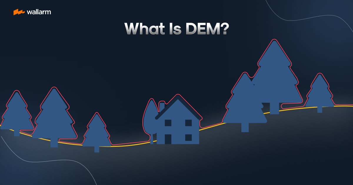
What Is DEM?
Commonly interpreted acronym DEM stands for Digital Elevation Model. It structurally contributes significantly to geospatial technology studies. Think of it as a digital twin, mirroring our world's topography. What's the methodology behind its operation, and why do we need it? Here's a simplified elucidation.

Let's peel back the layers of an intriguing subject: DEM, and discover what's its purpose?
In terms we can all relate to, the Digital Elevation Model (DEM) is akin to a 3D blueprint of landscapes, formed using data procured from ground elevations. This data-driven model is a cornerstone in Geographic Information Systems (GIS), offering an abridged view of both small and significant components of the Earth’s crust.
The Python snippet above is a quick snapshot of how DEM data may shape up. The values in the array indicate variations in terrain heights.
Two popular formats of DEM include raster DEM and vector DEM. The initial one is a collection of square patterns, portraying certain patches of land, with square values indicating the mean elevation of the region. In contrast, the later uses shapes such as points, lines, and polygons to represent geographic elements, housing the elevation data within their geometric attributes.
The myriad use-cases of DEM can be found in the production of topographical maps, 3D ground models, hydrological simulations, land use planning, and even game-designing realistic geographical terrains. DEM embodies an impeccable reproduction of our globe's surface, rendering it crucial for numerous scientific, security, and civil projects.
Stripped down to its basics, DEM is the digital doppelganger that mirrors Earth's terrain with a high degree of accuracy. As a staple in geospatial technologies, it caters to a wide range of use-cases. Grasping the basics of DEM is a stepping stone towards unlocking its capabilities and leveraging its benefits.
Simplifying DEM: A Guide for Beginners
Digital Elevation Model, or DEM, might sound like a complex term, but it's actually a straightforward concept. In this chapter, we'll break down the basics of DEM, making it easy for beginners to understand.
First, let's start with a simple definition. A Digital Elevation Model (DEM) is a 3D representation of a terrain's surface, created from terrain elevation data. It's like a digital map that shows the highs and lows of a landscape, from mountains and valleys to everything in between.
To better understand DEM, let's use an analogy. Imagine you're looking at a physical map. You see lines, colors, and symbols that represent different geographical features. Now, imagine that map in 3D, where the height of the terrain is accurately represented. That's what a DEM does. It takes data about the height of the terrain and transforms it into a 3D model.
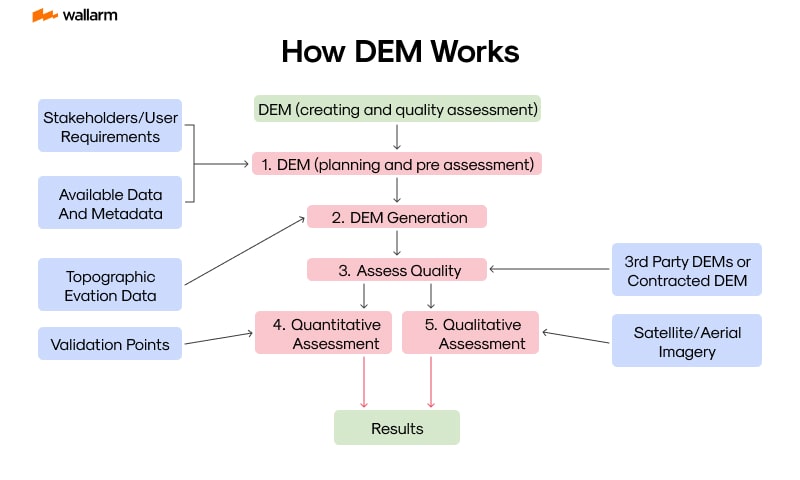
Here's a simple breakdown of how DEM works:
- Data Collection: The first step in creating a DEM is to collect elevation data. This can be done using various methods, such as aerial surveys, satellite imagery, or LiDAR (Light Detection and Ranging).
- Data Processing: Once the data is collected, it's processed to remove any errors or inconsistencies. This ensures that the final model accurately represents the terrain.
- Model Creation: The processed data is then used to create a 3D model of the terrain. This model can be viewed and analyzed using specialized software.
- Analysis and Interpretation: The final step is to analyze and interpret the model. This can involve studying the terrain's features, assessing its suitability for certain activities, or predicting how it might change in the future.
Now, let's look at a simple code snippet that demonstrates how DEM data might be processed. This is a Python code using the GDAL library, a popular tool for processing geospatial data:
This code opens a DEM file, reads the elevation data into a 2D array, and then prints the minimum and maximum elevation values. It's a simple example, but it gives you an idea of how DEM data can be processed and analyzed.
In conclusion, DEM is a powerful tool for representing and analyzing terrain. It's used in a wide range of fields, from geography and geology to urban planning and environmental science. By understanding the basics of DEM, you're taking the first step towards harnessing this powerful technology.
Getting Technical: The Mechanisms of DEM
Digital Elevation Model (DEM) is a representation of the Earth's surface topography or terrain. It's a digital model or 3D representation of a terrain's surface, typically created from terrain elevation data. Now, let's delve into the technical aspects of DEM.
1. Data Collection:
The first step in creating a DEM is data collection. This is typically done using remote sensing techniques such as aerial photography, LiDAR (Light Detection and Ranging), or satellite imagery. For instance, LiDAR uses laser light to measure the distance between the sensor and the Earth's surface, generating highly accurate elevation data.
2. Data Processing:
Once the data is collected, it needs to be processed to remove any errors or inconsistencies. This involves cleaning the data, removing outliers, and interpolating missing values. The processed data is then used to create a grid of regularly spaced elevation points.
3. DEM Generation:
The processed data is then used to generate the DEM. This involves creating a grid of cells, where each cell represents a specific area on the ground, and assigning an elevation value to each cell. The elevation value is typically the average elevation of the points within the cell.
4. DEM Analysis:
Once the DEM is generated, it can be used for various analyses. This includes slope analysis, aspect analysis, watershed delineation, and viewshed analysis, among others.
Comparison Table: DEM vs. Other Models
In conclusion, the creation and use of a DEM involve a series of technical steps, from data collection and processing to DEM generation and analysis. Understanding these mechanisms can help us better appreciate the value and potential applications of DEMs.
Harnessing The Potential: A Practical Approach to DEM Application
Digital Elevation Models, frequently denoted as DEMs, offer a plethoraer of uses in various areas of expertise. DEMs have catalyzed a remarkable transformation in fields that range from environmental conservation to urban development. This chapter will dive into the practicality of DEM utilization, manifest through real-world applications and explanations of how they are employed in a multitude of sectors.
1. Management of the Environment
The role of DEMs in environmental management cannot be overstated—they play a pivotal function in modeling the direction and volume of water flow for predicting flood occurrences, assessing soil erosion and analyzing landslide risks. For instance, hydrometeorologists exploit DEMs for the creation of the boundaries of watersheds and sub-watersheds, computation of flow direction and accumulation of flow to identify regions susceptible to flooding.
2. City and Regional Planning
Town and regional planners take advantage of DEMs to inspect an area's topography for infrastructural growth, inclusive of design of roads, construction of buildings and even planning of expansive cities. The intel, provided by DEMs, concerning the landscape is invaluable as it impacts the location and design of infrastructures.
3. Telecommunication Industry
In the field of telecommunication, DEMs are used for strategizing the positioning of transmission towers. The landscape of a region can considerably influence the propagation of signals. Thus, with the aid of DEMs, engineers can pinpoint the best sites for these towers to guarantee optimal coverage.
4. Agricultural Sector
DEM plays a significant part in precision farming in the sphere of agriculture. This is a method where farmers effectively manage field discrepancies to produce more consumables using fewer resources. DEMs can spot differences in the terrain, which can then be appropriately utilized to deliver the correct quantity of water, seeds and fertilizer to optimize the yield.
To sum it up, the uses of DEMs are extensive and diverse. By offering an elaborate depiction of Earth's surface, DEMs have turned out to be an invaluable resource in numerous sectors. As we witness continuous technological evolution, we can anticipate finding even more creative applications of DEMs.
Unleashing the Potential: The Role of DEM in Novel Technologies
The twenty-first century is witnessing an upsurge in the significance of Digital Elevation Models (DEM) amidst novel technologies. Whether it's autonomous driving, climate modeling, or even drone navigation, DEMs have become an irreplaceable factor in the evolution and deployment of these advanced technologies. Let's delve into the different ways DEMs are influencing the technological landscape of the future.
1. Self-Driving Vehicles
Self-driving vehicles substantially bank on precise mapping and topographical data for secure traveling. Digital Elevation Models are pivotal in furnishing the three-dimensional terrain specifics which aid these vehicles in comprehending their surroundings effectively. For instance, a DEM can assist a self-driving car in recognizing a mountainous route from a flat path, thus enabling it to calibrate its velocity appropriately.
2. Climate Alteration Simulation
Furthermore, DEMs are essential in climate change simulations as they offer the necessary data to emulate diverse climatic situations, such as elevated sea levels or intensified rainfall. Accurate topography understanding assists scientists in predicting and determining the influence of climatic variations on different geographical regions.
3. Virtual Reality (VR) and Augmented Reality (AR)
Within the sphere of VR and AR, DEMs are utilized to manufacture authentic 3D realms. Whether it's designing a videogame world or creating an immersive city tour, DEMs supply the vital data to shape an accurate depiction of the physical environment.
4. Drone Trajectory
Drones, much like self-driving vehicles, depend on precise mapping and topographical data for harmless travel. DEMs provide the vital data for drones to circumvent obstacles and reach their destination without mishaps.
5. Infrastructure Blueprinting
DEMs are also instrumental in infrastructure blueprinting - they assist engineers and architects in comprehending the geographical features of their construction sites, enabling them to design secure and efficient structures.
To wrap up, DEMs are playing a pivotal role in the evolution and application of novel technologies. As these cutting-edge technologies transform further, the significance of DEMs is anticipated to amplify. By rendering precise and detailed 3D topographical data, DEMs are aiding in unleashing the technological future.
Dealing with Falsehoods: Debunking Widely Held Misunderstandings about DEM
In the realm of geospatial examination and mapping, Digital Elevation Models (DEM) serve as a key element. Despite their importance, a number of incorrect beliefs and false impressions about DEM continue to persist. In this chapter, we will shatter these widely held misunderstandings to reveal what DEM actually is.
Misunderstanding 1: DEM and DSM are identical
One regular false impression is that DEM and Digital Surface Model (DSM) are one and the same. Although they may appear similar, they don't depict the same thing. A DEM illustrates the pure ground level excluding any physical entities such as edifices or foliage, whereas a DSM incorporates all things on the surface.
Misunderstanding 2: A DEM of a higher resolution is invariably superior
The belief that a DEM with a higher resolution is perpetually superior is another widespread misconception. Although a higher resolution can give more intricate details, it introduces more noise and demands an increased storage space. The selection for resolution should be decided based on what the particular project necessitates.
Misunderstanding 3: DEMs only have use in topographic mapping
DEMs are indeed utilised for topographic mapping but that's not their only use. They find applications in a variety of fields such as hydrography, geology, city planning, and even in the design of video games and films.
Misunderstanding 4: All DEMs are of an equal standard
All DEMs are not of the same quality. A DEM's standard can fluctuate depending on several aspects like the process of data procurement, the resolution, and the authenticity of the data. It's crucial to comprehend the constraints of the DEM you have at your disposal.
Misunderstanding 5: DEMs are strictly in 2D
DEMs are often illustrated in 2D but, they have the potential to be shown in a 3D format. A 3D DEM gives a more lifelike portrayal of the terrain and proves advantageous for visual presentations and simulations.
By debunking these misconceptions, we take a step closer to fully realizing the true possibilities of DEMs. Their importance and flexibility are bound to increase as we innovate and further delve into the world of geospatial analysis.
Future Forecasting: How DEM Will Shape Tomorrow's World
As we delve into the future of Digital Elevation Models (DEM), it's essential to understand that DEM's potential is vast and transformative. The technology's ability to provide detailed and accurate three-dimensional representations of the earth's surface has significant implications for various industries and sectors. This chapter will explore how DEM will shape the future world, focusing on its potential applications, advancements, and the challenges it may face.
1. Enhanced Disaster Management
DEM's ability to accurately model the earth's surface will play a critical role in disaster management. For instance, in flood forecasting, DEM can help predict the areas most likely to be affected, allowing for timely evacuations and preparations.
2. Revolutionizing Urban Planning
Urban planners can use DEM to visualize the impact of various development projects, including building constructions, road networks, and public utilities. It can help in assessing the environmental impact, planning drainage systems, and optimizing the use of available land.
3. Advancements in Autonomous Vehicles
Autonomous vehicles rely heavily on accurate mapping for navigation. DEM can provide the necessary terrain information, enhancing the safety and efficiency of these vehicles.
4. Improved Climate Change Modeling
DEM can help scientists understand the impact of climate change better by providing accurate models of areas prone to sea-level rise, desertification, or other climate-related changes.
Despite these promising applications, DEM will also face certain challenges in the future. These include:
- Data Accuracy: The accuracy of DEM data is crucial for its applications. Any errors or inaccuracies can lead to significant consequences, especially in critical areas like disaster management or autonomous vehicle navigation.
- Data Volume: As the resolution of DEM data increases, so does the volume of data. Managing and processing this massive amount of data will be a significant challenge.
- Privacy Concerns: As DEM becomes more detailed, it could potentially reveal sensitive information, raising privacy concerns.
In conclusion, DEM holds immense potential to shape our future world, revolutionizing everything from disaster management to urban planning. However, it's also essential to address the challenges it faces to fully harness its potential.
Comparison Table: DEM Applications Now and in the Future
List of Challenges Facing DEM in the Future:
- Ensuring data accuracy
- Managing and processing large volumes of data
- Addressing privacy concerns
As we look forward to a future shaped by DEM, it's clear that this technology holds the key to many solutions, but also presents new challenges that we must be prepared to tackle.
FAQ
References
Subscribe for the latest news

.png "AWS with Wallarm")